Image Segmentation with Watershed Algorithm – OpenCV Python
Image segmentation is the process of dividing an image into several disjoint small local areas or cluster sets according to certain rules and principles. The watershed algorithm is a computer vision technique used for image region segmentation. The segmentation process will take the similarity with adjacent pixels of the image as an important reference to connect pixels with similar spatial positions and gray values. Constitute a closed contour(outline), and this closure is an important feature of the watershed algorithm. In short, it is an algorithm that correctly determines the “outline of an object“. In this article, you will learn Image Segmentation with Watershed Algorithm in OpenCV using Python.
Working of Watershed Algorithm
The watershed algorithm uses topographic information to divide an image into multiple segments or regions. The algorithm views an image as a topographic surface, each pixel representing a different height. The watershed algorithm uses this information to identify catchment basins, similar to how water would collect in valleys in a real topographic map.
The watershed algorithm identifies the local minima, or the lowest points, in the image. These points are then marked as markers. The algorithm then floods the image with different colors, starting from these marked markers. As the color spreads, it fills up the catchment basins until it reaches the boundaries of the objects or regions in the image.
The catchment basin in the watershed algorithm refers to a region in the image that is filled by the spreading color starting from a marker. The catchment basin is defined by the boundaries of the object or region in the image and the local minima in the intensity values of the pixels. The algorithm uses the catchment basins to divide the image into separate regions and then identifies the boundaries between the basins to create a segmentation of the image for object recognition, image analysis, and feature extraction tasks.
The flooding process continues until all catchment basins have been filled with different colors, creating a segmentation of the image. The resulting segments or regions are assigned unique colors, which can then be used to identify different objects or features in the image.
The whole process of the watershed algorithm can be summarized in the following steps:
- Marker placement: The first step is to place markers on the local minima, or the lowest points, in the image. These markers serve as the starting points for the flooding process.
- Flooding: The algorithm then floods the image with different colors, starting from the markers. As the color spreads, it fills up the catchment basins until it reaches the boundaries of the objects or regions in the image.
- Catchment basin formation: As the color spreads, the catchment basins are gradually filled, creating a segmentation of the image. The resulting segments or regions are assigned unique colors, which can then be used to identify different objects or features in the image.
- Boundary identification: The watershed algorithm uses the boundaries between the different colored regions to identify the objects or regions in the image. The resulting segmentation can be used for object recognition, image analysis, and feature extraction tasks.
Implement the watershed algorithm: OpenCV
OpenCV (Open Source Computer Vision Library) is an open-source computer vision and machine learning software library. OpenCV contains hundreds of computer vision algorithms, including object detection, face recognition, image processing, and machine learning.
Here are the implementation steps for the watershed Algorithm using OpenCV:
Сегментация изображений python opencv
- We will learn to use marker-based image segmentation using watershed algorithm
- We will see: cv.watershed()
Theory
Any grayscale image can be viewed as a topographic surface where high intensity denotes peaks and hills while low intensity denotes valleys. You start filling every isolated valleys (local minima) with different colored water (labels). As the water rises, depending on the peaks (gradients) nearby, water from different valleys, obviously with different colors will start to merge. To avoid that, you build barriers in the locations where water merges. You continue the work of filling water and building barriers until all the peaks are under water. Then the barriers you created gives you the segmentation result. This is the «philosophy» behind the watershed. You can visit the CMM webpage on watershed to understand it with the help of some animations.
But this approach gives you oversegmented result due to noise or any other irregularities in the image. So OpenCV implemented a marker-based watershed algorithm where you specify which are all valley points are to be merged and which are not. It is an interactive image segmentation. What we do is to give different labels for our object we know. Label the region which we are sure of being the foreground or object with one color (or intensity), label the region which we are sure of being background or non-object with another color and finally the region which we are not sure of anything, label it with 0. That is our marker. Then apply watershed algorithm. Then our marker will be updated with the labels we gave, and the boundaries of objects will have a value of -1.
Code
Below we will see an example on how to use the Distance Transform along with watershed to segment mutually touching objects.
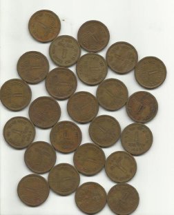
Consider the coins image below, the coins are touching each other. Even if you threshold it, it will be touching each other.
We start with finding an approximate estimate of the coins. For that, we can use the Otsu’s binarization.